
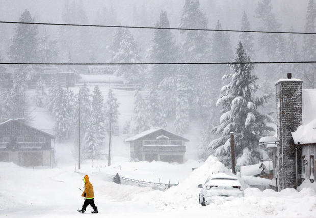
Relentless snowfall and hurricane-force winds that pounded the Sierra Nevada mountain range across Northern California and parts of Nevada began to somewhat let up on Sunday, though blizzard warnings were set to remain effective through at least midnight in areas along the border between those two states.
Winter storm warnings were in effect Sunday for a much larger portion of Northern California, and meteorologists did not expect them to expire until early Wednesday morning.
Blizzard conditions were forecasted in regions that sit at higher elevations — at least 6,500 feet — in the Sierra Nevadas throughout Sunday. But meteorologists said that even areas as low as 4,000 feet above mean sea level should prepare to see between 1 and 2 feet of snow before the weekend wrapped up, according to the National Weather Service in Sacramento.
Considerably less snowfall was forecasted Sunday for the upper foothills of the West’s sprawling mountain range, which runs farther inland into central and northern parts of California. Those areas were expected to see between 1 to 4 inches of snow, the weather service said, although an advisory issued Sunday morning still warned that places impacted by the current bout of blustery winter weather should brace for possible wind gusts throughout the day of up to 45 miles per hour.
Despite the Weather Prediction Center’s latest bulletin noting that this season’s biggest storm so far in the Sierra Nevada would be tamer on Sunday than it had been for several days since a massive blizzard first struck the region, meteorologists also anticipated another turn of dangerous winter weather come Monday.
An additional 2 to 4 feet of snow was headed for portions of the Sierra Nevadas at elevations of 4,000 feet or higher on Monday and Tuesday, according to NWS Sacramento. The weather service said travel would be “extremely difficult to impossible” as the storm threatened to bring white-out conditions and “near zero visibility at times.” With that, forecasts warned of lengthy travel delays, road closures and power outages, along with downed trees and tree branches.
“Mountain travel is HIGHLY discouraged!” the weather service said.
Communities across Northern California felt the brunt of the impacts of the blizzard, which roiled through the Sierra Nevadas beginning on Thursday and pounded higher-elevation areas with heaps of snow as well as destructive winds characteristic of hurricanes.
“Extremely heavy snowfall rates of 2-6 inches an hour combined with very strong winds exceeding 100 mph at times will maintain impossible travel conditions in the Sierra Nevada,” the Weather Prediction Center said on Saturday.
The Saffir-Simpson Hurricane Wind Scale, which estimates possible property damage associated with powerful storms, classifies sustained wind speeds between 96 and 110 mph as Category 2, meaning winds are “extremely dangerous” and “will cause extensive damage.”
National Weather Service meteorologist William Churchill told the Associated Press on Saturday that more than 10 feet of snow was expected at higher elevations in and around the Sierra Nevadas, posing a “life-threatening concern” for communities around Lake Tahoe. Meanwhile, the storm forced California officials to shut down a lengthy section of Interstate 80 as ski resorts closed and tens of thousands of homes were left without power. The weather service said Saturday that avalanche dangers in the region’s backcountry were “high to extreme” and noted that serious hazards would remain through at least Sunday evening.
The interstate highway, which closed on Friday night, has not yet reopened. When it will remained unclear on Sunday, CBS San Francisco reported. Officials have advised anyone in the affected areas who must travel to do so with a survival kit inside their vehicles to use if necessary in an emergency.
Storm conditions were expected to be less severe in the Sacramento Valley, although people in those areas were told to expect heavy rain and possible thunderstorms, according to CBS San Francisco.
