
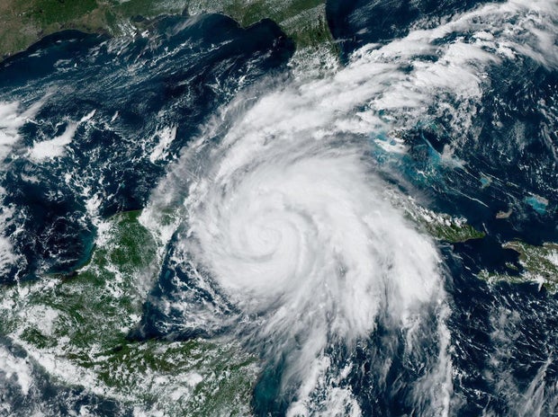
Ian intensified into a major hurricane packing sustained winds of around 115 mph early Tuesday morning as it churned toward western Cuba. The storm was expected to continue strengthening as it passed over Cuba on a track for the Gulf of Mexico, with Florida’s west coast in its path later this week.
Mandatory evacuations were ordered Monday in low-lying areas surrounding Tampa Bay, and officials asked others in the area to voluntarily evacuate, knowing it could take some time to move hundreds of thousands of people out of Ian’s path.
Ian, a Category 3 storm as of Tuesday morning, was forecast to become an even stronger Category 4 with top winds of 140 mph before striking Florida as early as Wednesday. Tampa and St. Petersburg appeared to be among the most likely targets for their first direct hit by a major hurricane in a century. Even if Ian doesn’t hit the area directly, it could still feel the effects of the storm, Florida Gov. Ron DeSantis warned.
“You’re still looking at really significant amount of rain, you’re looking at a lot of wind, you’re looking at a lot of storm surge, and so, yes, follow that track, but don’t think because that eye may or may not be in your area that you’re not going to see impacts,” DeSantis said during a Monday afternoon press conference. “You’re going to see significant impacts.”
The governor said the state had suspended tolls around the Tampa Bay area and mobilized 5,000 National Guard troops, with another 2,000 on standby in neighboring states. More than 27,000 power restoration personnel were put on standby to help after the storm, DeSantis said.
“Please treat this storm seriously. It’s the real deal. This is not a drill,” Hillsborough County Emergency Management Director Timothy Dudley said at a Monday news conference on storm preparations in Tampa, where some mandatory evacuations were ordered.
As many as 300,000 people may be evacuated from low-lying areas in Hillsborough County alone, Administrator Bonnie Wise said at a news conference. Schools and other locations were opened as shelters.
In Pinellas County, which includes St. Petersburg, officials issued evacuation orders that start taking effect Monday evening. Sheriff Bob Gualtieri said no one would be forced to leave, but they would remain at their risk.
“What it means is, we’re not going to come help you. If you don’t do it, you’re on your own,” Gualtieri said. “For all practical purposes, get out. Right now. Everybody needs to go.”
The evacuation zone is all along Tampa Bay and the rivers that feed it, encompassing MacDill Air Force Base and well-known neighborhoods such as parts of Hyde Park, Davis Islands and Ybor City.
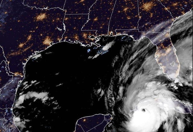
As of 2:30 a.m. Eastern on Tuesday morning, Ian was moving north-northwest at 13 mph and was located only about 35 miles south of Cuba’s southwestern shores, according to the National Hurricane Center. Its maximum sustained winds had increased to 115 mph.
Authorities in Cuba were evacuating 50,000 people in Pinar del Rio province, sent in medical and emergency personnel, and took steps to protect food and other crops in warehouses, according to state media.
“Cuba is expecting extreme hurricane-force winds, also life-threatening storm surge and heavy rainfall,” U.S. National Hurricane Center senior specialist Daniel Brown told The Associated Press.
The hurricane center predicted areas of Cuba’s western coast could see as much as 14 feet of storm surge Monday night or early Tuesday.
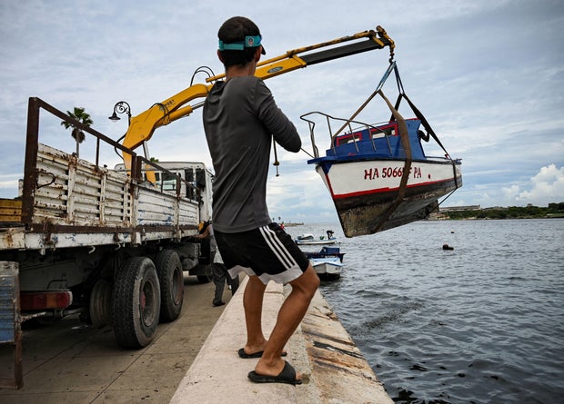
In Havana, fishermen were taking their boats out of the water along the famous Malecon, the seaside boardwalk, and city workers were unclogging storm drains ahead of the expected rain.
In Havana’s El Fanguito, a poor neighborhood near the Almendares River, residents were packing up what they could to leave their homes, many of which show damage from previous storms.
“I hope we escape this one because it would be the end of us. We already have so little,” health worker Abel Rodrigues, 54, said.
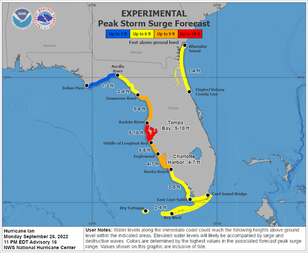
In the Tampa Bay area, a storm surge of up to 10 feet of ocean water and 10 inches of rain, with as much as 15 inches in isolated areas. That’s enough water to inundate low-lying coastal communities. Florida residents were getting ready, lining up for hours in Tampa to collect sandbags and clearing store shelves of bottled water.
Nervous anticipation led to long lines for gas, packed grocery stores and empty shelves, CBS News correspondent Omar Villafranca reports from Clearwater, Florida.
“We are going to get these sandbags in front of the garage, the garage door, the front door… and pray we’re good,” Gabriel Alley, who moved to Clearwater from California, told CBS News.
Ian’s impending arrival also prompted NASA to haul its Artemis 1 rocket off its launch pad and back to the protection of the agency’s Vehicle Assembly Building, likely ending any chance of launching the unpiloted moonshot before November.
“A lot of people on the Florida Peninsula and into the Florida Panhandle are at risk and need to be ready to take action quickly,” said Rick Knabb, a hurricane specialist with The Weather Channel, “and the slow motion that we expect from Ian means we could have wind, storm surge and rain-induced flooding.”
DeSantis has declared a state of emergency throughout Florida and urged residents to prepare for the storm to lash large swaths of the state with heavy rains, high winds and rising seas.
“We’re going to keep monitoring the track of this storm. But it really is important to stress the degree of uncertainty that still exists,” DeSantis said at a news conference Sunday, cautioning that “even if you’re not necessarily right in the eye of the path of the storm, there’s going to be pretty broad impacts throughout the state.”
Flash and urban flooding is possible in the Florida Keys and Florida Peninsula through midweek, and then heavy rainfall was possible for north Florida, the Florida Panhandle and the southeast United States later this week.
The hurricane center has advised Floridians to have hurricane plans in place and monitor updates of the storm’s evolving path.
President Biden also declared an emergency, authorizing the Department of Homeland Security and the Federal Emergency Management Agency, or FEMA, to coordinate disaster relief and provide assistance to protect lives and property. The president postponed a scheduled Tuesday trip to Florida because of the storm.