
Last Updated May 15, 2018 6:49 PM EDT
NEW YORK — After a sticky, summer-like day, a powerful front bore down on the northeastern U.S., bringing with it rain, hail and the possibility of tornadoes. CBS New York reports heavy rain, thunderstorms and flooding were expected across much of New York City, Long Island, Rockland and Westchester counties. A tornado watch was in effect for parts of upstate New York.
Flights have been delayed, trains service disrupted and drivers stranded in cars. Millions are in the storm zone. Watches and warnings are in effect from Pennsylvania to New England for severe storms and possible tornadoes.
CBS News correspondent DeMarco Morgan reports this is a fast-moving storm and warnings will stay in effect until 11 p.m. ET. There are power outages for more than half a million customers across New York, Pennsylvania and Connecticut.
Downed trees and roof damage was reported across the area.
Powerful winds may have been responsible for blowing the top off a water tower in Morningside Heights.
In New Jersey, a downed tree limb apparently sparked a transformer fire.
Here’s a look at hail spawned from Tuesday’s storm.
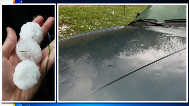
A look at hail from a storm that’s sweeping through the Northeast on Tue., May 15, 2018.
CBS New York
Passengers were frustrated at Grand Central Terminal, where several Metro-North lines were suspended due to the powerful storms.
At the height of rush hour, passengers were being told to avoid the terminal.
The storm forced the suspension of Metro-North service on the Hudson, Harlem and New Haven lines.
Delays were reported at all three major airports JFK, LaGuardia and Newark.
CBS New York reports “the signature is there” for tornadoes, though nothing has officially been confirmed. A storm over Danbury, Connecticut, was “very close to being a radar-indicated tornado.”
© 2018 CBS Interactive Inc. All Rights Reserved.
