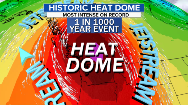
The heatwave baking the U.S. Pacific Northwest and British Columbia, Canada, is of an intensity never recorded by modern humans. By one measure it is more rare than a once in a 1,000 year event — which means that if you could live in this particular spot for 1,000 years, you’d likely only experience a heat dome like this once, if ever.
Portland, Oregon, has already broken its all-time record hottest temperature at 108 degrees on Saturday and the peak of the heatwave has not even been reached yet. Canada is expected to register the nation’s all-time highest temperature before the event is done. These are extremely dangerous numbers, especially in a region not used to heat like this, where many people do not have air conditioning.
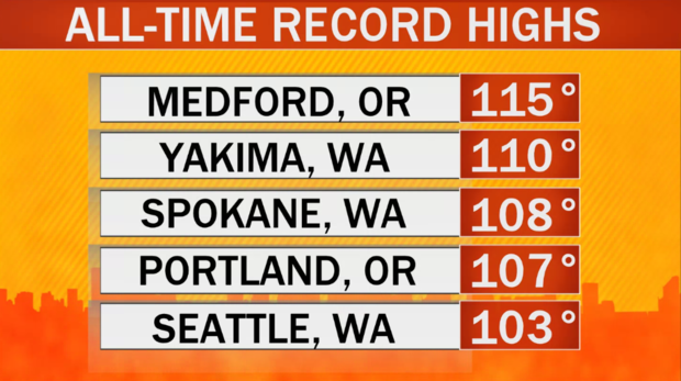
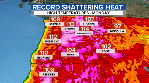
By Monday, some — if not all — of the all-time record highs seen below are forecast to break, with many more cities not listed here expected to achieve the same feat.
The heat is being caused by a combination of a significant atmospheric blocking pattern on top of a human-caused climate changed world where baseline temperatures are already a couple to a few degrees higher than nature intended.
This heatwave comes on the heels of another historic heatwave less than two weeks ago that baked the U.S. Intermountain West, Desert Southwest and California with hundreds of record highs.
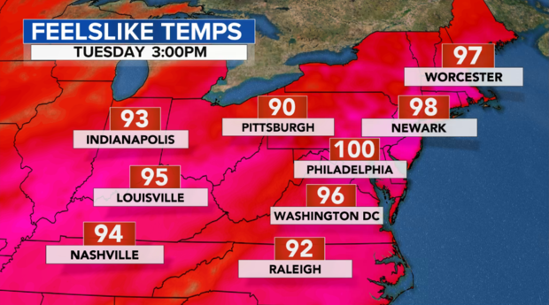
Meanwhile, the Eastern U.S. is also seeing the heat ratchet up, with feels like temperatures pushing 100 degrees by Monday and Tuesday in the major cities of the I-95 corridor. The back to back and dueling heatwaves are made more likely by a very wavy jet stream and our unnaturally heating climate.
Pacific Northwest Heatwave
Sunday and Monday are projected to be the hottest days of the heatwave along the Northwest coast from Portland to Seattle. Even before the peak of the heat had been reached on Saturday, many records have already been broken, with even hotter temperatures to come.
As the heat dome continues to build, cities like Portland will likely break their all-time heat record again, on back-to-back days. On Sunday the thermometer is expected to reach a staggering 112 degrees — that’s 5 degrees higher than the all-time record of 107 degrees, prior to Saturday’s 108.
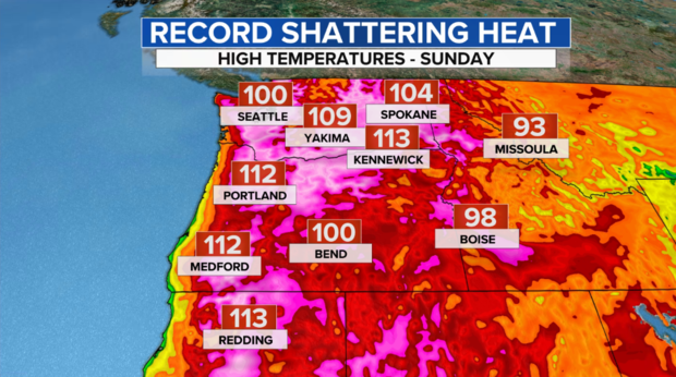
After a record high of 102 on Saturday, the thermometer is likely to shatter it’s all-time record high of 103 degrees in Seattle on Monday, with a forecast high of 108. In its history, Seattle has only reached 100 degrees three times. Remarkably, in this one heatwave, highs in the city will easily top 100 degrees 3 days in a row.
Some of the inland cities in eastern Washington and Oregon will likely max out in the 115-120 degree range. And while the heat will break along the coast of Washington and Oregon by midweek, the record heat will continue over inland Washington, Oregon, Idaho and Montana through late week.
For the past week, as computer models have consistently forecast seemingly unbelievable numbers, meteorologists struggled to grasp how a heatwave of this magnitude could even be possible, given this region has never experienced anything of this magnitude before. Were the models wrong? Or, given climate change, should we now expect the unexpected — is this now just becoming routine?
Turns out, the models were correct and we should expect extreme heatwaves, even unprecedented ones like this to become more routine. “There is no context really, in the sense that there is no analog in our past for what we are likely to see this week,” says Dr. Michael Mann, Distinguished Professor of Atmospheric Science at Penn State and author of the new book The New Climate War.
But calling it a new normal does not suffice says Mann, “Some people called this a ‘new normal. But it is worse than that,” explained Mann. “We will continue to see more and more extreme heat waves, droughts, wildfires and floods as long as we continue to warm the planet through fossil fuel burning and carbon emissions.”
As shown in the below illustration from the Oregon Climate Assessment, this is only the beginning of the heating which is expected if humanity continues burning fossil fuels. By 2100, temperatures are expected to be 7 to 10 degrees above what they naturally should, and that would mean a dramatic increase in extreme heatwaves.
In the case of this specific heat dome, which is a mountain of hot air stacked vertically through the atmosphere, it is a once in a 1,000 or even 10,000 type year event for this particular area. How do we know? It’s actually quite simple to explain.
The intensity of a heat dome is measured by how “thick” the atmosphere is at a given spot. The hotter the air in that column, the larger the thickness of air in that column, because heat expands. In our historical record of North America’s Pacific Northwest this heat dome registers a statistical standard deviation from the average of greater than 4.
In layman terms, that means it falls more than 4 deviations to the right of the center of a typical bell curve (shown below) and that equates to values with less than a 99.99% chance of happening.
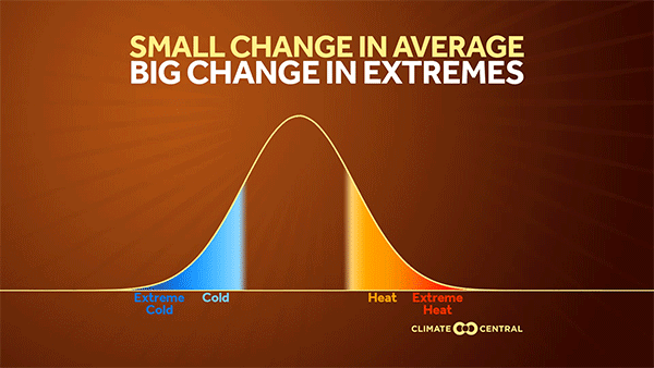
In other words, statistically speaking, there is a 1 in 10,000 chance of experiencing this value. So, if you could possibly live in that spot for 10,000 years, you’d likely only experience that kind of heat dome once, if ever.
It is worth noting that our historical record is limited and statistics like this are very sensitive to small changes. But if it seems like an overstatement to say there is a 1 in 10,000 chance of having a heat dome like this, it is certainly not an overstatement to say this is the kind of event you would expect to experience once in 1000 years.
But we will know the exact value soon, as some of the best extreme weather attribution scientists are likely to be hard at work doing rapid attribution — a new type of cutting edge science — this week to determine the actual values and to what degree climate change has contributed.
So what is causing this heatwave? Like any heatwave, it is being caused by a highly amplified jet stream pattern. These extreme jet stream perturbations are a natural, normal part of the atmosphere. But the climate science community is split as to whether these extreme jet stream perturbations are becoming even more likely because of climate change – a phenomena known as the wavy jet stream.
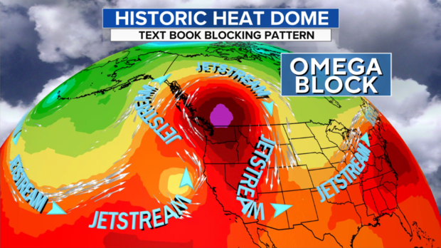
Along with a more wavy, buckling and slow-moving jet stream, comes a phenomena called “blocking”. This is when waves in the jet stream become so elongated that they break off, sit and spin. In this case there is a textbook type of block called an Omega block over the Pacific Northwest because it looks like the Greek letter Omega. Inside this Omega, the heat pools and intensifies.
There is a faction of climate scientists who believe that a warming climate — specifically the Arctic — results in a more wandering jet stream at certain times of the year. But it is hotly debated – there is an equal amount of research that does not arrive at this conclusion.
Mann and his colleagues have been involved in some of this research, in which he finds that a specific type of Northern Hemisphere blocking — what he calls Quasi Resonant Amplification — will increase by 50% this century under business as usual human-forced climate warming. “I do indeed believe that the phenomenon we describe in our work played a very important role in the record heat wave,” Mann said.
As for the lack of consensus in the climate research on the wavy jet stream and blocking, Mann thinks it has more to do with the current state of climate modeling “This is an area where current generation models are NOT capturing a real-world climate connection,” Mann explained.
Whatever the cause, the result of an extreme jet stream pattern, is extremes across many parts of the nation and globe. Over the past few days, the central U.S. has seen over a foot of rain with flash flooding along a stalled front. And, starting on Sunday and continuing through most of the upcoming week, the major East Coast cities will also sweat through a heatwave — although not nearly as intense — with feels like temperatures near 100 degrees from Washington D.C. to Philadelphia and New York City.
While natural swings between hot and cold patterns will continue, the trend is clear — extreme heatwaves are bound to become more common, more extreme and more deadly in the coming years. In practice, the solution to worsening extreme weather is a herculean challenge for humanity, but in theory it is simple: “We can prevent things from getting worse if we rapidly decarbonize our civilization,” Mann said.