
The first hurricane to threaten the U.S. since the start of the coronavirus pandemic is approaching Hawaii, prompting the governor there to issue an emergency declaration late Friday. Meanwhile, two storms are churning in the Atlantic and one could reach hurricane force before bringing significant flooding to Texas’ Gulf Coast.
In the Pacific, Hurricane Douglas grew into a major Category 3 on Thursday, packing maximum sustained winds of 130 mph. It’s expected to weaken as it passes over cooler water before reaching Hawaii, but meteorologists warn strong winds, heavy rainfall and dangerous surf could afflict the entire state beginning on Sunday.
Weather officials on Friday put the islands of Hawaii and Maui County (including Maui, Molokai and Kahoolawe) under a hurricane watch.
CBS News meteorologist and climate specialist Jeff Berardelli says Douglas will likely pass just north of the Big Island of Hawaii on Saturday and possibly make landfall Sunday as a hurricane or tropical storm on Maui. Watch for heavy rain, flash flooding and winds gusting over 75 mph. If it does make landfall at hurricane strength, it would only be the third time in record-keeping history that Hawaii has seen a landfalling hurricane.
On Friday night, Hawaii Governor David Ige announced a “pre-landfall emergency proclamation.”
“Our top priority is always the safety, health and well-being of our residents and visitors,” he said in a statement. “Please take immediate steps to protect your families, loved ones, employees and property. We ask everyone to closely follow emergency instructions as we prepare for Hurricane Douglas.”
The storm approaches as Hawaii is grappling with increasing COVID-19 numbers. On Thursday, the state reported 55 newly confirmed cases, its highest single-day increase since the pandemic began.
Unlike other hurricane-prone states like Florida where residents pile into cars to evacuate when storms approach, it’s impractical to leave Hawaii to get away from a storm. Shelter space is also limited.
So, as is typical, local authorities are urging most people to shelter at home if they can. Those living in homes built according to code after 1995 should be “pretty good to go,” said John Cummings, the public information office for Honolulu Emergency Management,
He recommended staying with friends and family if home isn’t safe. Seek refuge in an interior room, he said. Going to a city-run shelter should be a last resort, he added.
Hanna threatens Texas coast
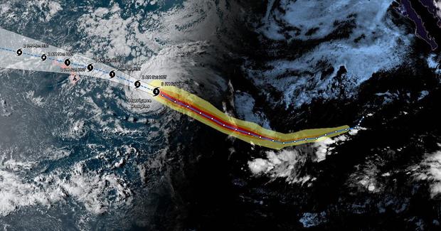
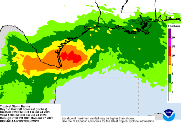
Meanwhile, Tropical Storm Hanna is expected to strengthen into a hurricane as it moves toward the Texas coastline near Corpus Christi. The storm is threatening to bring heavy rain, rough waters and strong winds to the area Saturday afternoon or early evening.
“The big threat here is rain and flash flooding,” CBS News weather producer David Parkinson said. “Texas does need storms like this to prevent recurring droughts but that doesn’t mean there won’t be isolated pockets of bad flooding.”
In a Friday afternoon advisory, the National Hurricane Center said Hanna is expected to produce 5 to 10 inches of rain, with isolated maximum totals of 15 inches through Sunday night in south Texas and parts of Mexico.
A hurricane warning has been issued from Baffin Bay northward to Mesquite Bay, Texas. A tropical storm warning stretched from the mouth of the Rio Grande to Baffin Bay, Texas; and from Mesquite Bay to San Luis Pass, Texas. The advisory also warned of “a danger of life-threatening storm surge along the Texas coast from Baffin Bay to Sargent.” The storm was expected to weaken once it moves moves inland.
Hanna and Gonzalo set records as season ramps up
Hanna broke the record as the earliest eighth Atlantic named storm, in what is shaping up to be an unusually active season. The previous record was Harvey on August 3, 2005, noted Colorado State University hurricane researcher Phil Klotzbach.
Tropical Storm Gonzalo, which is moving towards the southern Caribbean, was also the earliest Atlantic named storm for its place in the alphabet. It formed Wednesday, July 22, breaking the previous record held by Tropical Storm Gert, which formed on July 24, 2005. So far this year, Cristobal, Danielle, Edouard and Fay also set records for being the earliest named Atlantic storm for their alphabetic order.
“The second phase of Atlantic Hurricane Season is now in full swing, about 2 to 3 weeks earlier than normal, partly because of near record-breaking hot tropical Atlantic water temperatures,” Berardelli explained. “We are more than a week ahead of the record pace of named storms and all signs are pointing to one of the most active seasons on record in the Atlantic Basin.”
“More concerning than any of the present storms is another wave is emerging off Africa right now which the models are hinting could be a more significant player over the next couple of weeks,” he said.
Gonzalo is expected to bring rain and wind to the the southern Windward Islands late Friday and Saturday. As some strengthening is forecast, there is still a chance that Gonzalo could become a hurricane, but the storm is expected to weaken as it moves into the Caribbean Sea.
A hurricane watch has been issued for Barbados and St. Vincent and the Grenadines. A tropical storm warning is in effect for several places, including St. Lucia, Tobago and Grenada. Forecasters said Gonzalo could bring 2 to 5 inches of rain.
